- copy")
Menu
- fig. beginning
- prescription
- Visual Monitoring Solutions
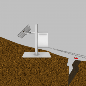
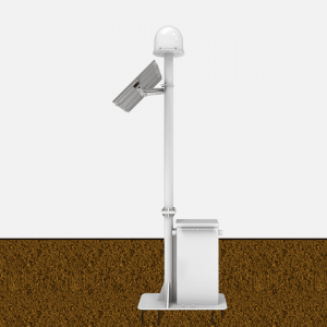
- Slope monitoring solutions
- Open Pit Mine Safety Monitoring Solutions
- Reservoir Dam Monitoring Solutions
- Tailings pond monitoring solutions
- Six system solutions for mines
- Dangerous Houses Monitoring Solution
- Electric vehicle safety monitoring
- Bridge Safety Monitoring Solutions
- Tunnel Monitoring Solutions
- Dust monitoring solutions
- Pit Monitoring Solutions
- Tower Monitoring Solutions
- Intelligent Piling System Solution
- Beidou/GNSS Ionospheric TEC and Scintillation Monitor
- Coal Mine Airspace Monitoring Solutions
- Smart Energy Solutions
- Intelligent Mine Solutions
- Intelligent Chemical Park Solution
- InSAR Deformation Monitoring Solutions
- Digital Twin Solutions
- Lightning monitoring and assessment solutions
- Wind turbine safety monitoring solutions
- Smart Agriculture Solutions
- GNSS-R monitoring solution
- Amphibious specialized drone monitoring
Slope safety monitoringHydraulic and hydropower monitoring- Reservoir dam monitoring
- Gate station safety monitoring
- Electric vehicle safety monitoring
Structural safety monitoring - typical case
- Product Center
- Company Profile
- Internet of Things Monitoring Cloud Platform R&D


 Su Gong Network Security No. 32011202000665